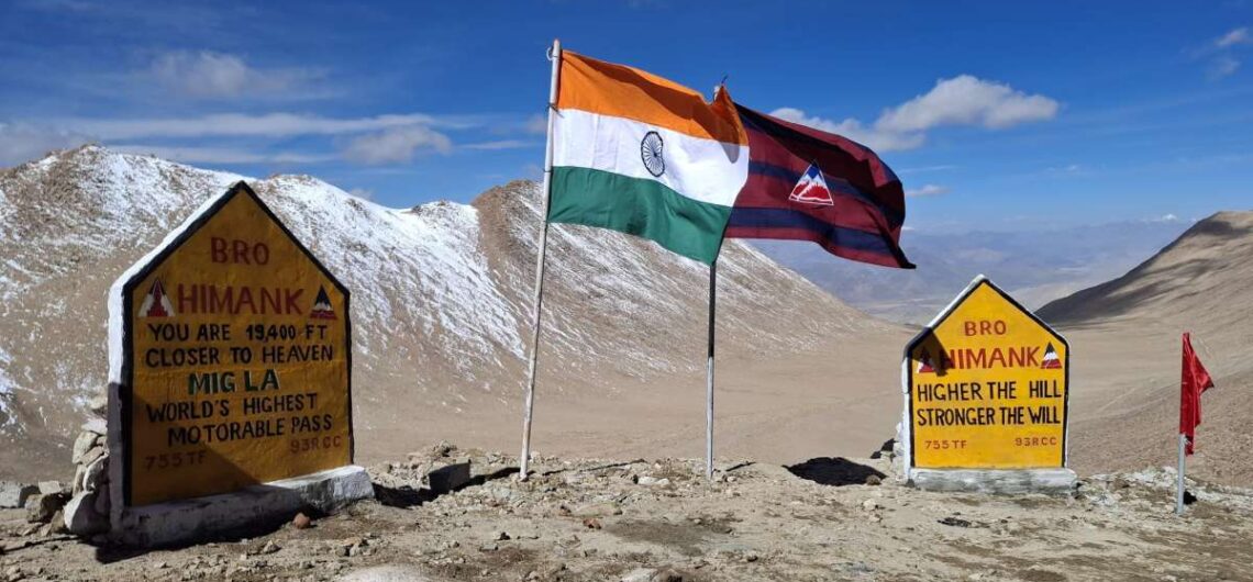
Fukche is a remote location in eastern Ladakh (Nyoma subdivision, Leh district) quite close to the India-China Line of Actual Control (LAC). Historically a military advanced landing ground (ALG), it is gaining attention lately thanks to new road construction and potential for offbeat tourism. If you like border landscapes, remote military-heritage sites, and high-altitude adventure, Fukche is one place to watch. Where is Fukche & Why It’s Important Fukche Advanced Landing Ground is located in the Demchok sector of eastern Ladakh, adjacent to the village of Koyul. The site sits in the Koyul Lungpa river valley, very near where the river meets the Indus (locally called Sengge Zangbo). It is extremely close to the LAC—just 2.5 km away. That means it is of strategic military and geopolitical importance. Initially built before the 1962 Sino-Indian War, it became inactive post-war. It was revived (reopened) by the Indian Air Force in 2008 for military and logistical purposes. Features & Current Status The runway is unpaved/gravel and operates primarily under Indian Air Force control; there are no civilian flight services. Elevation is about 13,700 feet (≈ 4,176 meters) above sea level. There is some local presence (villages like Koyul) nearby, though these are very small and remote. Facilities are very basic or minimal. New Infrastructure & Road Connectivity Fukche is not just about military operations anymore; it is becoming more connected by roads, which may open up possibilities for tourism (if permitted). Key infrastructure projects: Likaru-Mig La-Fukche Road A 64-km long road has connected Likaru to Fukche, passing over Mig La Pass at ~19,400 feet. Road construction done on October 01, 2025, Mig La pass became world’s highest motorable roads. Chushul-Dungti-Fukche-Demchok (CDFD) Road This highway being upgraded to national highway standards with paved shoulders. It runs along the southern bank of the Indus
Fukche is a remote location in eastern Ladakh (Nyoma subdivision, Leh district) quite close to the India-China Line of Actual Control (LAC). Historically a military advanced landing ground (ALG), it is gaining attention lately thanks to new road construction and potential for offbeat tourism. If you like border landscapes, remote military-heritage sites, and high-altitude adventure,
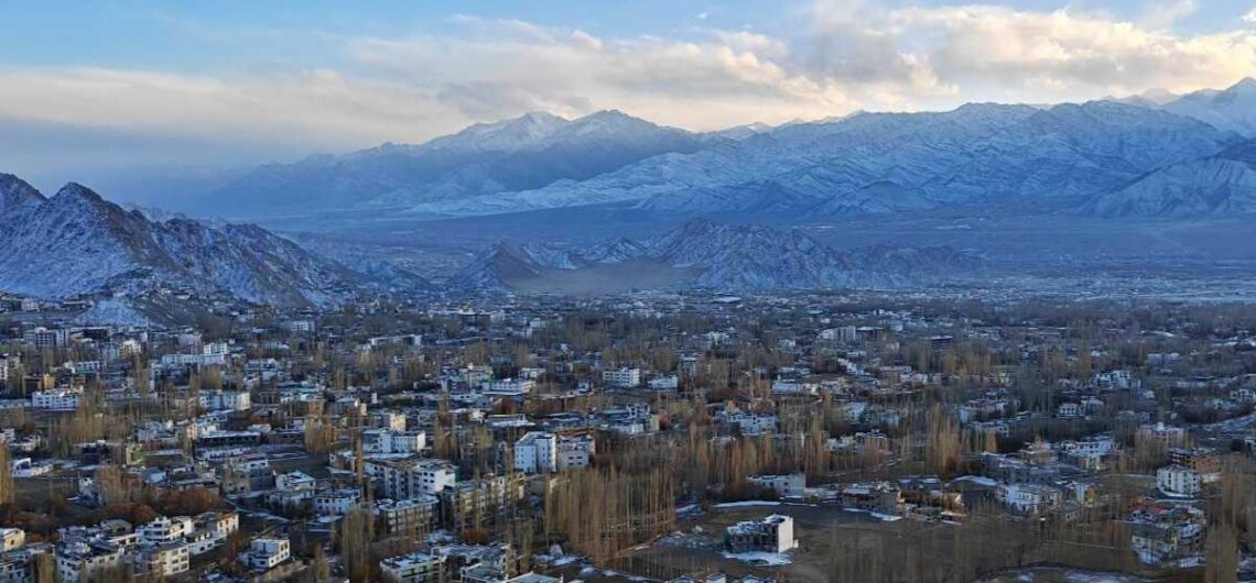
Nestled in the lap of the Himalayas, Leh, the capital of the Union Territory of Ladakh, is a dream destination for travelers from around the world. Perched at an altitude of 11,500 feet (3,500 meters), Leh is more than just a town—it’s an experience of a lifetime. Known for its stunning monasteries, snow-capped peaks, crystal-clear lakes, vibrant local culture, and adventurous terrain, Leh offers something unique to every visitor. Whether you’re an adventure enthusiast, a spiritual seeker, a photographer, or simply someone longing for peace and beauty, Leh in Ladakh is a place that will leave you spellbound. Introduction to Leh – Gateway to Ladakh Leh is located in northern India, bordered by the mighty Karakoram and Zanskar mountain ranges. Once an important stop on the ancient Silk Route, Leh has a rich history of trade and cultural exchange with Tibet, Central Asia, and Kashmir. The region is home to ancient Buddhist monasteries, palaces, and stupas that reflect the deep-rooted Buddhist traditions of Ladakh. Today, Leh serves as the main base for exploring the high-altitude wonders of Ladakh, including Nubra Valley, Pangong Lake, Tso Moriri, and Zanskar Valley. The town is also known for its friendly locals, colorful festivals, and a blend of traditional Ladakhi and modern influences. Geography and Altitude Leh is located at an elevation of around 11,500 feet above sea level, which means the air is thin and oxygen levels are lower than at sea level. For first-time visitors, it’s important to acclimatize properly at Leh town for at least two days before engaging in strenuous activity or heading to higher altitudes. The landscape around Leh is breathtaking—rugged mountains, barren hills, and deep valleys, all under a clear blue sky. Despite being a cold desert, the region enjoys plenty of sunshine during the day, though temperatures can
Nestled in the lap of the Himalayas, Leh, the capital of the Union Territory of Ladakh, is a dream destination for travelers from around the world. Perched at an altitude of 11,500 feet (3,500 meters), Leh is more than just a town—it’s an experience of a lifetime. Known for its stunning monasteries, snow-capped peaks, crystal-clear
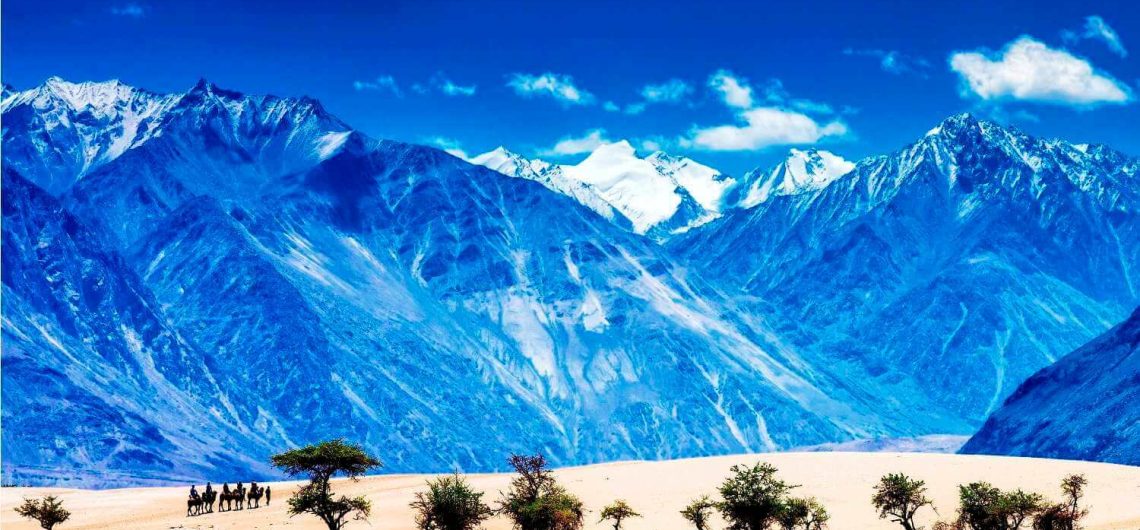
Nubra Valley is in the north of Leh town after traversing 17,982ft high Khardungla pass (Khardongla), which is one of the highest motorable roads in the world. Nubra was earlier known as Ladorma, which means “valley of flowers”. Nubra Valley or Nobra Valley is a famous tourist destination of Ladakh famous for its vast green valleys, sand dunes, double humped camels, beautiful river, monasteries, camping, ATV ride, zipline, and border tourism. Diskit, Hunder, Turtuk, Sumur, Panamik and Siachen Base Camp are the main tourist destinations in Nubra valley. Diskit, Hunder and Sumur are the main settlements of Nubra valley. Diskit is about 130km from Leh. Shyok and Nubra (or Siachen) are the main rivers of the valley. Nubra Valley is comparatively warmer than Leh as the valley is at low altitude. Its vast and plain valleys, sand dunes of Hunder, double humped camels (Bactrian camels) and greenery at many places like oasis in the desert make Nubra must visit place for tourists. Nubra Valley has become a must visit tourist destination of Ladakh and almost all tourists visiting Ladakh would not miss to visit Nubra. Nubra mostly remains connected by road. However, sometimes heavy winter snowfall at Khardungla pass blocks road temporarily. Besides hotels and cottages, tourists prefer staying in tents (camps) in Nubra Valley. However, Nubra Valley has many good hotels, guesthouses and homestays as well. The valley has Buddhist majority. Wheat, peas, mustard, potato, barley, apple, apricot, walnut and almond crops can be seen frequently in the valley. Balti people (both Shia and Sufia) reside at Turtuk in the western end of the valley, close to Indo-Pakistan border. Siachen Glacier, the toughest and highest battlefield of the world lies north of the valley. Diskit monastery (Diskit village) and Samstanling monastery (Sumur village) are the main monasteries of Nubra
Nubra Valley is in the north of Leh town after traversing 17,982ft high Khardungla pass (Khardongla), which is one of the highest motorable roads in the world. Nubra was earlier known as Ladorma, which means “valley of flowers”. Nubra Valley or Nobra Valley is a famous tourist destination of Ladakh famous for its vast green